It is the 21st of June 2011. Today is going to be an all day cruise in Glacier Bay.
We've been cruising to the south all night, making a turn to the east in the early hours while we slept.
Eventually we make another turn to the north to enter the bay.
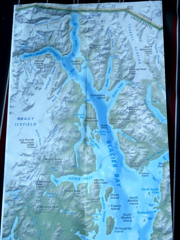
Glacier Bay is immense. We've entered south of Willoughby Islnad and will take most of the morning to get to the head of the bay. Our objective is the Margerie Glacier just below the Canadian border.
Part of the plan is to pick up a park ranger who lives in Gustavus AK (southeast of Willoughby at the mouth of the bay) on the way in. They do this while underway with a small boat matching speed while the ranger boards.
Gustavus is the location of the nearest airport in this area, and therefore has a bit more development than most of the rest of the area. Not exactly a metropolis, but definitely development.
It's interesting to look back over some the pics on the way in. Just like in the vicinity of Mt McKinley, everywhere there is a glacier or a lot of ice, there tend to be a lot of clouds. The view to the south below is a good contrast.
Our ranger gives a 30 minute slide show in the Mondrian Lounge before heading to the Crows Nest to narrate the trip.
We'll spend around 3 hours in the bay. It's interesting to take another look at the map above. Notice there are lines with dates across the bay at multiple places all the way up to Margerie Glacier. These are the locations of the glaciers at various periods. In 1860 we would have had a pretty short trip to a line just north of Sebree Island and Geikie Inlet.
You could not have made it to Margerie Glacier by sea even in 1907. As you look at the pictures below, recall the rivers of ice back at Denali during the helicopter tour and imagine our entire route today filled with miles of thousand foot thick ice. This first several are of Margerie.
You can see the river of ice above the face of the glacier in the pic below. Lot of other things you can see as well. Over on the left side you can see where the ice has been gouging the rock, leaving the black streaks.
This next one is a shot of the bay to the south, the way we'll depart in a short time.
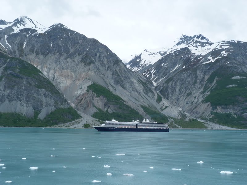
The ship and little boat below give some perspective on the scale of the area.
The Captain rotates the ship counter clockwise using thrusters to put the starboard side to the glacier. The reasoning becomes more clear below. He's apparently been chatting with other ships in the bay heading for our location and is positioning for a departure. The gull in the center of the pic seems interested.
The color of the ice in glaciers never ceases to amaze. The ranger mentioned over the PA system that we are very fortunate today to have so much sunlight to view the glacier.
While the little boat above gives a certain perspective, the sister ship to ours below gives an even better perspective.
We eventually depart back to the south . . .
. . . but not all the way.
We enter another small inlet on the way south which may be Johns Hopkins. Most of the pictures below are taken to the south.
This is a beautiful glacier. Although not as tall or wide as Margerie, it seems to have more color and character.
This particular glacier has kicked up a lot of rock on its way to the bay.
This final shot is to the rear of the ship as we departed for the overnight cruise to Haines AK.
That about sums up the day in Glacier Bay. We're off to Haines AK and 9 holes of golf tomorrow.


No comments:
Post a Comment
What do you think?