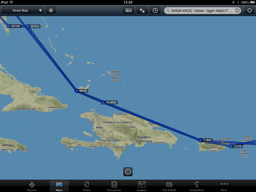
Sunday, 10 Feb 2013, and Day 4. That's us waiving up in Staniel Cay (MYES). We're headed for Vieques PR
(TJVQ) for three nights down in the bottom right corner of the map. Routing is by way of Inagua BHs (MYIG, customs
and fuel to get to PR), Aguadilla / Borinquen PR (TJBQ, our first experience with inbound US Customs and a top
off with the cheapest gas in the Caribbean at $7), and finally to Vieques
(TJVQ).
We consulted with local aquatic experts on matters of technique. Although these local luminaries were quite free with their experiences, we ultimately rejected suggestions to dive in this way because we lacked adequate experience. Lack of floats on the plane was also a contributing factor. Soon after we got down to some serious flight planning.

 I got up early to make a call from the local pay phone using a card bought at, you guessed it, the bar. Got through to Lockheed for weather and filed. We had to leave early because we had several long legs to fly. Few airports have lights in the Caribbean, and too many delays could put us in a bad position.
 I filed two international flight plans over the phone. We got off when we planned, headed for Inagua (aka, Matthew Town).


Seldom were we out of either sight or gliding distance of an island or a boat. The sea down here is very shallow, so much so Jim Parker jokingly suggested either getting a life raft or stilts.
The water color is unreal.

We interpreted some sights along the way as good signs.

The refueling spreadsheet I made was a great
help. I had loaded the distances and prices of gas for primaries and
alternates for the entire trip before departing FDK, and used a dip tube to
verify fuel remaining in each tank during the flight. The spreadsheet said I'd get to
Inagua with just barely enough fuel to make it on fumes to Borinquen PR. Even though
Inagua fuel is extraordinarily fine (aka, expensive ;-), this was one place I needed to get it. We added only 18
gals for reserves. As it turned out, we could have taken less for an hour's reserve since we
topped off with 70 gal at Borinquen. Still, it was good to have figured
this out before leaving Waynesboro than scratching portions of my anatomy trying to figure it out on a
ramp.
Inagua was a brief but interesting stop. Only
a customs guy and Rico were at the airport. We ran in and did the
paperwork pretty quickly, then waited for 20 minutes or so while the customs office was kind enough to drive a mile or so into
town to get the tanker cart driver to bring fuel to the airport.
Rico is a friendly, talkative fella. He was washing the salt off the undercarriage of his truck right in front of the terminal, about 30 ft from the plane. He said you have to do this or you get the experience of the main company on the island -- their vehicles last four years before they are completely rusted out. That company, by the way, is apparently in some combination of the desalination and salt businesses. Rico is comfortable with Inagua, with only 1000ish people on the whole island, and the only settlement being Matthew Town. I asked about other settlements, but he thought it was good there was only one -- two would lead to folks not knowing each other, and only bad things could come of that. He seemed to value knowing all the folks in his community -- not unlike living in a small town anywhere, and not a bad life at that.
Rico is a friendly, talkative fella. He was washing the salt off the undercarriage of his truck right in front of the terminal, about 30 ft from the plane. He said you have to do this or you get the experience of the main company on the island -- their vehicles last four years before they are completely rusted out. That company, by the way, is apparently in some combination of the desalination and salt businesses. Rico is comfortable with Inagua, with only 1000ish people on the whole island, and the only settlement being Matthew Town. I asked about other settlements, but he thought it was good there was only one -- two would lead to folks not knowing each other, and only bad things could come of that. He seemed to value knowing all the folks in his community -- not unlike living in a small town anywhere, and not a bad life at that.
After launching from Inagua we had a long three hour leg
to PR, and a mildly long 35 minute leg over open water to the island of Haiti and the Dominican Republic.
 Fortunately, Haiti / Dominican Republic lies just to the south of a direct route to Borinquen. This time we did get a flight plan in the air from Miami, but it was a full route clearance (D ALBBE A636 D TJBQ). It was mainly a direct route, but with a lot of mandatory reporting points.
 Once established on the route, the view was very impressive.
 The wisdom of having a lot of reporting points became clear when, around 100 nm out, Miami Center asks us to contact Port au Prince Haiti, and on reaching reporting point RETAK, contact Santo Domingo DR. We never did talk to Port au Prince and there was no one to talk to until Santo Domingo.
 We later found it advisable to file with way points and airways because you were going to get them eventually anyway. That was probably a good thing under the circumstances.
 Direct over the ocean may not be as good as direct over Kansas if one is looking for places to put her down in the event of an emergency.
Once again, there were signs that favored our trip.

We finally got to Borinquen PR at the NW corner of the main island. This is an old Strategic Air Command (SAC) base with an 11.7K ft runway. It's been converted to a commercial airlift waypoint (FEDEX and others) and does a brisk business. Fortunately, US Customs is located just off taxiway B at around 3 - 4K ft.
Customs was a pretty easy process. We showed passports and a blue Immigration card for the two of us, then on to the baggage X-ray machine and we're done except for the mandatory plumbing inspection. While we did the bag drag into and out of customs, a line guy rounded up a fuel truck and topped us off with 70 gal of their finest, cheap $7 / gal gas right there on the customs ramp.
Once again, there were signs that favored our trip.
We finally got to Borinquen PR at the NW corner of the main island. This is an old Strategic Air Command (SAC) base with an 11.7K ft runway. It's been converted to a commercial airlift waypoint (FEDEX and others) and does a brisk business. Fortunately, US Customs is located just off taxiway B at around 3 - 4K ft.
Customs was a pretty easy process. We showed passports and a blue Immigration card for the two of us, then on to the baggage X-ray machine and we're done except for the mandatory plumbing inspection. While we did the bag drag into and out of customs, a line guy rounded up a fuel truck and topped us off with 70 gal of their finest, cheap $7 / gal gas right there on the customs ramp.
From here we called Borinquen
tower to see if they could get us VFR flight following. By the time we launched and contacted San Juan approach we were in the system. There were a lot of clouds below us over the island as we crossed from NW to SE, but we were lucky we got a clear view of the Arecibo Radio Telescope, the largest radio telescope in the world, located in the municipality of Arecibo PR.

 We continued across PR, but there was a lot of cloud cover so other sights were mostly obscured. At the southeast end of the island we had a short stretch over water to La Isla de Vieques.
 The airport is located on the north (left in the picture) side of the island, but our reservations are on the south in the town of Esperanza.
 As long as we're on a VFR flight plan, we take a little detour to see where we'll be staying.
 That's the town located on the main island to the left of the string of anchored boats.
Antonio Rivera Rodriquez is a nice little airport on the north shore. There is no tower but there is a small commercial terminal. It's Sunday and although there is actually a lot of scheduled service, no one comes out to suggest where to park. We find a spot on the west ramp (about 70 yards from the terminal) and chock her into the wind (there are neither tie downs nor the rings for tie downs at most airports down there). Turns out that location is great.
Antonio Rivera Rodriquez is a nice little airport on the north shore. There is no tower but there is a small commercial terminal. It's Sunday and although there is actually a lot of scheduled service, no one comes out to suggest where to park. We find a spot on the west ramp (about 70 yards from the terminal) and chock her into the wind (there are neither tie downs nor the rings for tie downs at most airports down there). Turns out that location is great.
It's about 1730 so while Ann is starting to
unload, I run off to find our rental car. Our first obstacle is the front
door to the terminal. The guard and TSA lady don't quite seem to know
what to make of a guy scratching at their door with no commercial aircraft in
sight. We get that worked out and we're directed to Maritza's Car Rental.
George, a former Army guy, is manning the rental post. He notes how
lucky we are because he was about to close up for the night. While we run
through the procedure, George and I chat about how expensive it is to shop on Vieques, so
tomorrow is a shopping day for his family. He and the wife (his wife, not mine) will board a ferry in the
morning and load up with groceries on PR.
We eventually walk downstairs to get to the Jeep and I bring her round to the drop off area. Parking is almost non-existent, but George chats up the security gal in baggage claim on our behalf. I get to park for a few minutes in a vaguely legal location while I run out to get Ann and the bags. More confused looks from TSA, but my pilot license seems to be enough to get out and back in with the bags. A quick load and we're off to Esperanza on the south side of the island.
The roads here at Vieques are interesting. Except for a few, most seem to be one lane (reasonably sized for a single lane) but handling two way traffic. Few lines are painted on these roads. You also get to share the roads with wild horses that roam freely all over the island. Almost everyone has fences and gates so the horses don't get in and eat their landscaping! With Ann navigating, we wound our way from the north side to the south side of the island. Our hotel, the Malecon House, is on west end of the main drag of Esperanza.

 This is a very nice place. It was apparently only a year old, owned and operated by Robin and Marsha Shepard. There is a great view of the bay right across the main drag from our balcony.
 It turns out Esperanza is very tiny, but features some terrific restaurants. We walked to one recommended by Robin on the east end of town.
The walk along the bay is a wide and very well maintained path called the Malecon.
I have to apologize in advance for the picture below. I thought I had a shot of the Malecon walkway, but apparently not. I got this one from www.vieques-island.com/ showing the recently remodeled Malecon.


 OK, back to my pictures. While walking along the Malecon we enjoyed the view, and a little bit of the history of the coast. We would find in the next few days there is a lot of this kind of history strewn about Vieques.
This being Sunday, there seemed to be a party in the central part with a fella playing loud music from a big stereo system. There was a good crowd of local families (with and without kids) and a smattering of tourists talking, dancing, drinking a beer or two, and generally enjoying themselves.
We strolled back to the other end of town (maybe 5 minutes) and finally hit the rack after a long day.
Helpful tip when traveling in the Caribbean. Get yourself some of that insect repellant without Deet. Before going out (or right after a shower, or anywhere else for that matter) spray yourself liberally against mosquitos. Most restaurants and bars have a can somewhere close. Before going to bed it's not a bad idea to spray the covers as well.

We eventually walk downstairs to get to the Jeep and I bring her round to the drop off area. Parking is almost non-existent, but George chats up the security gal in baggage claim on our behalf. I get to park for a few minutes in a vaguely legal location while I run out to get Ann and the bags. More confused looks from TSA, but my pilot license seems to be enough to get out and back in with the bags. A quick load and we're off to Esperanza on the south side of the island.
The roads here at Vieques are interesting. Except for a few, most seem to be one lane (reasonably sized for a single lane) but handling two way traffic. Few lines are painted on these roads. You also get to share the roads with wild horses that roam freely all over the island. Almost everyone has fences and gates so the horses don't get in and eat their landscaping! With Ann navigating, we wound our way from the north side to the south side of the island. Our hotel, the Malecon House, is on west end of the main drag of Esperanza.
This is a very nice place. It was apparently only a year old, owned and operated by Robin and Marsha Shepard. There is a great view of the bay right across the main drag from our balcony. The walk along the bay is a wide and very well maintained path called the Malecon.
I have to apologize in advance for the picture below. I thought I had a shot of the Malecon walkway, but apparently not. I got this one from www.vieques-island.com/ showing the recently remodeled Malecon.
OK, back to my pictures. While walking along the Malecon we enjoyed the view, and a little bit of the history of the coast. We would find in the next few days there is a lot of this kind of history strewn about Vieques.This being Sunday, there seemed to be a party in the central part with a fella playing loud music from a big stereo system. There was a good crowd of local families (with and without kids) and a smattering of tourists talking, dancing, drinking a beer or two, and generally enjoying themselves.
We strolled back to the other end of town (maybe 5 minutes) and finally hit the rack after a long day.
Helpful tip when traveling in the Caribbean. Get yourself some of that insect repellant without Deet. Before going out (or right after a shower, or anywhere else for that matter) spray yourself liberally against mosquitos. Most restaurants and bars have a can somewhere close. Before going to bed it's not a bad idea to spray the covers as well.
More later.


